Saturday, September 12, 2009

Tasmania fotos - finally!

the view of Mt. Wellington from our street


2 strahan st, north hobart, TAS 7000 Australia
we now expect letters


about to get wet at Friendly Beach

tassie local

friendly beach


again

Hobart along the River Derwent


rain forest eucalypts - 500 years old and some of the world's tallest trees - about 250 ft

fun waves at Eagle Hawk Neck


locally infamous Port Arthur penal colony


clay's $200 boat deal


our little garden out back

restless natives in the Wineglass bay parking lot


cloudy, rainy day at Wineglass bay


Friday, July 31, 2009

Arnhem Land

Here was our introduction to Australia:

11 PM: Fly out of Singapore's glossy metropolis (bye bye Asian odessey!)
4:30 AM: Stumble into customs line at Darwin airport (declaring all wood & spices)
5:30 AM: Arrive at Brett and Birgit's house – all of us strangers soon to become friends
6:00 AM: Shower. Unpack. Rummage through camping gear we shipped from Hawaii. Repack.
7:30 AM: Meet Clay's phd advisor and pile into jeep.
8:00 AM: “Go bush"

Most folks make the trip to Australia's "Top End" just to see Kakadu National Park, a world heritage site of sweeping savannas, Aboriginal rock art and the "escarpment" - an area of raised bedrock close to 2 billion years old littered with crazy stone formations and dissected by rain forest-filled canyons. The escarpment marks the western boundary of Arnhem Plateau...and the stopping point for most park visitors. But at 4 hours into our jeep trek, 8 hours into our new lives in Australia, when we lifted our travel-weary heads to take in the awesome lie of the stone country - the beginning of Arnhem Land - half of our journey still lay ahead.

Bound for Kolorbidahdah - an Aboriginal outstation about 5 hours past Kakadu. We were meeting friends of my professor, Joshua and his wife Reab, whose family's ancestral lands lie just beyond the settlement.

We spent 8 days at Dugalarjaraj, where a huge rock covered in artwork balances above a beautiful campsite in the sandsheet savanna bordered by a little set of pools on the Caldell river. Aborigines name specific locations, like Dugalajaraj, along watercourses, rather than the river itself - hence the whitefella name for the stream. Far from mere landmarks or lines on maps, however, named places on an Aboriginal homestead carry the weight of the country in stories - dreamtime tales of creation and ancestral spirits who still watch over the landscape - everpresent in the worldview of the caretakers - Joshua and his family.

Just to be able to visit this place - Dugalajaraj - is truly a gift. But with Joshua and Reab camped closeby, they also allowed to roam around the country unaccompanied to conduct fieldwork. This sounds nominal but is really a big deal. Aborigines worry about outsiders on their land - not for the damage we might do, but for our own safety. Their responsibility for us lies somewhere between asking for permission and for protection. Spirits both benign and malevolent inhabit this place, and their acknowledgment ensures the safe passage of guests.

It is difficult for outsiders to comprehend the degree of spiritual connection with country that some of the more fortunate Aborigines in Arnhem Land still posess. A few short minutes away from the outstation and it feels like the deepest wilderness you can imagine. But pay close attention and nestled everywhere among the otherwordly rock formations is artwork - clear signs of the hands of humans - Joshua's and Reab's ancestors - who have wandered this landscape for at least 50,000 years. Fifty-thousand years....just think about that.

got to fly back to darwin over the savannas and croc-filled rivers that lead to the north coast


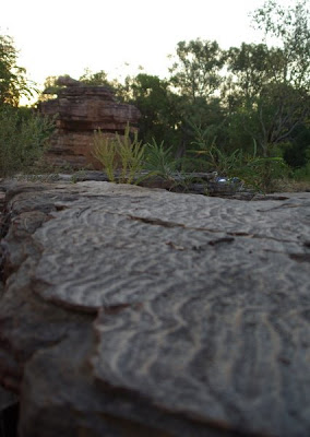
1,600,000,000 year old stones


termite mounds aligned with the earth's magnetic field


typical Australian savanna woodland - the trail's been made by feral water buffalo


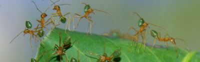
green ants - very charismatic but they bite


sunset time at Dugalajaraj


Ripples in the rock - evidence of shallow waters that covered the region millions of years ago


more rocks


carnivorous sundew plant


Joshua and Reab's son Leroy


"cleaning country" - Joshua and his family lit these fires after harvesting yams in the forest nearby


it seems strange to lots of people but many savanna species are adapted to survive fires - cleaning country with small, patchy fires like this prevents large wildfires later on and is probably the best way to manage the region's plants and wildlife.

Sunday, June 21, 2009

the beginning of the end

 
ok ok - its been a while and we've covered loads of kilometers in the meantime.  but here's some shots from the "beginning of the end" - our last few weeks of wandering.  Upon recommendation of friends we made in Laos, we arrived in southern Thailand and headed straight to Tonsai, a little beach surrounded by limestone cliffs, accessible only by boat.  It was a funny thing - we had absolutely no idea that Tonsai is this rock climbing mecca.  It was equivalent to showing up on the north shore of oahu and saying "oh, there's good surf here?"  So we hooked up with some climbing friends who got us out onto the rock, played on the slacklines set up everywhere (on the beach, at all the bars, and the infamous overwater stretch in the photos), and even went on a "deep water solo" trip to the nearby islands that have all these routes you can climb with no ropes and then jump (or fall) into the sea.

We've since continued on through malaysia and singapore and have finally arrived safe and sound in Australia - promise there will be more photos soon to follow to catch you up with the rest of our travels...


tonsai beach at sunset


a view over Railay beach with Tonsai tucked away at the upper right


from the vista above, a jungle walk and three slippery cliffs took us to this
lagoon in the middle of the peninsula


Pra Nang Cave - on our way to the overwater slackline


the infamous overwater slackline
look closely for the little strip of purple,  after swimming out
you could only climb up onto the rocks at high tide


our friend pete - in good form going for step #3.


clay - in poor form after about step #5.  It was the hardest slackline we'd ever tried.  
We stepped, fell, swam, climbed up and fell again for almost 2 hours.
One dude that followed us out did a full crotch plant on his 2nd attempt - 
the worst slackline fall I've ever seen - definitely shook us up a bit.


Our friends Carman (above) and Pete (below) on the first deep water solo route


some were pretty easy climbs until you got to about 10 meters
suddenly easy became very scary.


Sunday, May 17, 2009

Lovely Laos

Its a bit belated - we've already left, come back to Thailand, and passed on into Malaysia. But Laos is truly a special place - a bit like stepping back in time. We spent about 3 weeks mostly north of the main backpacker route - it was a hard place to leave...friendly people, beautiful rivers, limestone mountains, forest and villages, and some of the best food we've had so far.


the Mekong - with Thailand on the opposite bank


Houai Xai main street - the border town in Laos


"sin mu" = pork


Chinese tractor-trucks are everywhere


still maybe the best food on our trip - local style lunch during a trek in Nam Tha forest


our guide Mr. Pang in the Nam Tha forest


Talia plays the local foot-volleyball game in Vien Phoukah


the kids loved seeing their photo.


Clay paddles, Talia relaxes - Ou River, Nong Kiaw


view from our bungalow - Nong Kiaw


another sunset on the Ou River


Nong Kiaw


Louang Prabang


slow boat from Nong Kiaw to Louang Prabang


Another favorite meal - Laap (meat salad) with Kao niaw (sticky rice) and Beer Lao of course


stunning waterfall outside Louang Prabang


kinda scary jump because the pool was about 5 feet deep at the landing


Sleeping Buddah in a limestone cave - Vang Vien


northern laos busrides can be sickening